
PICKERING
HERITAGE RIDE
PICKERING
HERITAGE RIDE
the backroads of north pickering and uxbridge
the backroads of north pickering and uxbridge
LOCATION: PICKERING
ROUTE DISTANCE: 110KM
COMPLETION TIME: 5-6H
The Pickering Heritage Ride is a 110km all-roads route through a mix of urban and rural landscapes. You will start your journey along Duffins Creek in Pickering and slowly move north past Goodwood before returning south. You will pass through the lands once hunted and fished by the Hurons. You will ride through forgotten ghost towns and pass by churches and farmsteads that date back to the mid/late 1800s. The majority of what you will see is still largely undeveloped. But that is rapidly changing. Within the next 10 years many of the farms north of Pickering will be paved over to make way for homes –and as has been the case for the last 50 years, the threat of the Pickering Airport is a possibility.
It is highly recommended that you use a GPS to get through this route. You should also have tires that are above 35mm. There are some dirt sections that are better suited to fatter tires. There are stops along the way for food and washrooms. This route is designed to be taken at a relaxed pace.
There are sections that have no-trespassing signage (such as the Hydro Fields), so you must take full responsibility for your own actions along this route.
I would rate this ride as intermediate. It's not overly challenging, but the trail/singletrack sections can be a test if you're not used to riding off-road. If you're an average rider and you only take quick breaks then 5 hours would be an estimated completion time. If you spend more time detouring and eating at the suggested spots, you could get an additional couple of hours.

0-8km
Pickering to Cherrywood
The journey starts on multi-use paths, quiet side streets and wooded trails. You will follow Duffins' Creek, then head north along Dixie Rd., turning onto the hydro fields*. Follow the gravel path towards a steep embankment proceed up and at the top turn left. Passing through this short stretch will take you through a wooded section leading you to impressive views of Duffins Creek and an old trestle bridge. Exiting the woods you will continue on to concession road 3, which will take you into Cherrywood.The wooded section has a bit of an interesting past you can read more about it here.
*A word of warning on the hydro field section – it seems to be used heavily by dog walkers. You may encounter an off leash dog or two. Also it can get quite soggy; it might be best to avoid if it has been raining heavily the day prior. If that's the case continue up Dixie and avoid the hydro-field section completely. There's some long grasses in this area, be Tick Aware. You will also want to be cautious around the train tracks since it is an active line. There is also a serious drop-off, as you're looking out over Duffins' Creek.

8km-13km
Cherrywood to Beare Hill Park
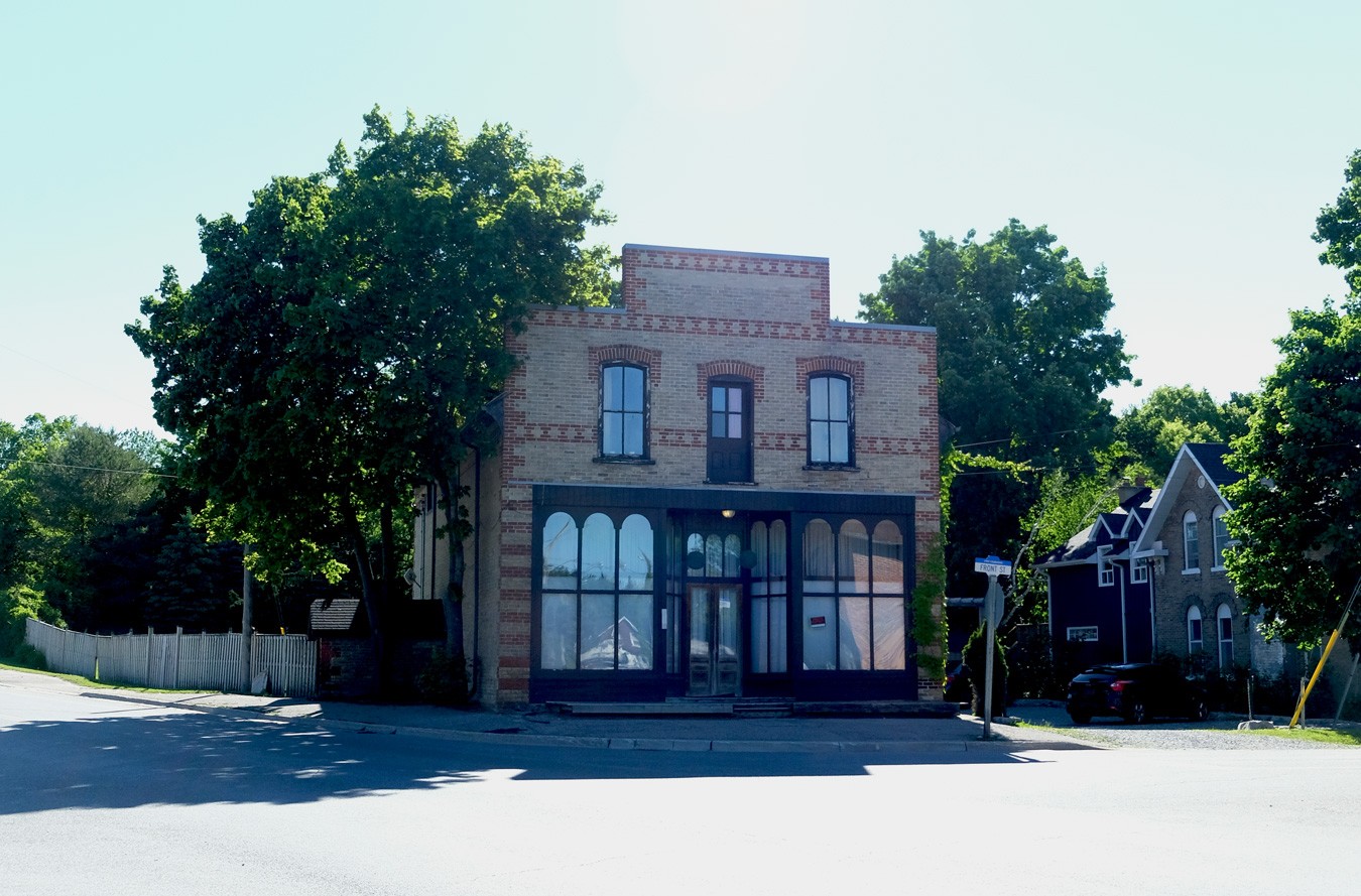
The hamlet of Cherrywood was founded in the 1830s, all that appears to remain today of the original buildings is the Methodist Church (which is now a private residence) and some older homes that have been reclad. At one point however it would have included blacksmith shop, carpenter shop, post office and a general store.
Exiting Cherrywood you will continue west until you reach the Scarborough Pickering Townline. Head south to Beare Hill Park. During summer there is a house that sells Butter Tarts and Pies on the street-side (along S.P.T.); never tried, but they sound good!
13-25km
Beare Hill to Whitevale
Beare Hill is a retired land-fill that has been converted into a park. As you ride through the park you will pass a very large hill. Work your way up this hill as it provides one of the best 360 views in Durham region.
Working your way back down the hill you will make your way into the Rouge Park. This is more of a hiking trail (Cedar Trail), so you will have to get off your bike at some points and walk. Stay on the path as much as possible and avoid any long-grass, as this area is known to have a pretty high tick population.
Once you're out of the park you will be on Meadowvale Rd. you will now start your journey north towards the town of Whitevale. You will pass an un-marked community called Belford just before Whitevale; I can't find too much info on this place other than its existence.
8km-13km
Cherrywood to Beare Hill Park
The hamlet of Cherrywood was founded in the 1830s, all that appears to remain today of the original buildings is the Methodist Church (which is now a private residence) and some older homes that have been reclad. At one point however it would have included blacksmith shop, carpenter shop, post office and a general store.
Exiting Cherrywood you will continue west until you reach the Scarborough Pickering Townline. Head south to Beare Hill Park. During summer there is a house that sells Butter Tarts and Pies on the street-side (along S.P.T.); never tried, but they sound good!
13-25km
Beare Hill to Whitevale
Beare Hill is a retired land-fill that has been converted into a park. As you ride through the park you will pass a very large hill. Work your way up this hill as it provides one of the best 360 views in Durham region.
Working your way back down the hill you will make your way into the Rouge Park. This is more of a hiking trail (Cedar Trail), so you will have to get off your bike at some points and walk. Stay on the path as much as possible and avoid any long-grass, as this area is known to have a pretty high Tick population.
Once you're out of the park you will be on Meadovale Rd. you will now start your journey north towards Whitevale. You will pass an un-marked community called Belford just before Whitevale; I can't find too much info on this place other than its existence.

25km-34km
Whitevale to Atha
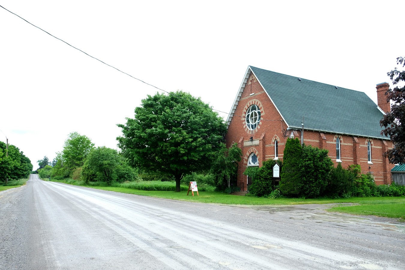
Whitevale was founded in 1820, a lot of the old structures still exist and entering this town is like stepping back in time. At one point Whitevale was home to impressive factories, mills, and general stores. The route through Whitevale will give you an opportunity to see many of these buildings that still remain (though not being used for their intended purposes).
As you exit Whitevale and head up North Road and past Highway 7, you will now be entering the proposed Pickering Airport lands. The area north, east, and west of here provide many kilometers of gravel farm roads to explore. Many of which look the same now as they did 100+ years ago. If you ride this area in the fall there are many Apple trees that provide a tasty treat. As you turn on to Concession Road Seven just after the bridge (within 10 meters) you will come to the continuation of North Road/Sideline 30. This short stretch starts off with some loose up-hill gravel that can be challenging, but it flattens out after approx. 30-40m.
As you proceed along North Road / Sideline 30 you will need to cross a set of train tracks. This track is active; however, the crossing point provides clear views – but as always use caution when crossing. As you navigate through this section, you will be passing by what was once a Huron-Wendat village dating back to the 1500s. In these woods was once a complex village of long houses and structures with a population that may have reached several hundred people at one point (possibly even upwards of 2000). Excavation of the site was done in the 1970s, it was named the Draper site at the time.
Once you reach Concession Road 8 you are now in the ghost-town of Atha. It does not appear that much exists here today. All that remains is an abandoned school house dating to the 1800s. At one point it was home to a general store, and blacksmith. You will need to detour slightly east of the route if you want to see the school house (approx. 200m). Heading west along Concession Road 8 you will jump on the Rouge Urban Trail.
25km-34km
Whitevale to Atha
Whitevale was founded in 1820, a lof of the old structures still exist and entering this town is like stepping back in time. At one point Whitevale was home to impressive factories, mills, and general stores. The route through Whitevale will give you an opportunity to see many of these buildings that still remain (though not being used for their intended purposes).
As you exit Whitevale and head up North Road past Highway 7, you will now be entering the proposed Pickering Airport Lands. The area north, east, and west of here provide many kilometers of gravel farm roads to explore. Many of which look the same now as they did 100+ years ago. As you turn on to Concession Road Seven just after the bridge (within 10 meters) you will come to the continuation of North Road/Sideline 30. This short stretch starts off with some loose up-hill gravel that can be challenging, but it flattens out after approx. 30-40m.
As you proceed along North Road / Sideline 30 you will need to cross a set of train tracks. This track is active; however, the crossing point provides clear views – but as always use caution when crossing. As you navigate through this section, you will be passing by what was once a Huron-Wendat village dating back to the 1500s. In these woods was once a complex village of long houses and structures with a population that may have reached several hundred people at one point (possibly even upwards of 2000). Excavation of the site was done in the 1970s, it was named the Draper site at the time.
Once you reach Concession Road 8 you are now in the Ghost Town of Atha. It does not appear that much exists here today. All that remains is an abandoned school house dating to the 1800s. At one point it was home to a general store, and blacksmith. You will need to detour slightly east of the route if you want to see the school house (approx. 200m). Heading west along Concession Road 8 you will jump on the Rouge Urban Trail.

34-42km
Atha to Stouffville
The journey to Stouffville will take place on the Rouge Urban Trail. It’s mostly a crushed gravel multi-use path that winds through farm fields. There are many good spots along this trail to take a break and stretch the legs. Because this is a multi-use trail you will need to use caution as it can become quite busy at times with hikers, runners and dog walkers.
You will enter the trail through what was once a small community called Mongolia. There does not appear to be any remnants of this community, possibly a few old farm homes remain, and Parks Canada has set up one of their Site offices here.
Mongolia has an interesting past you can read about it here.
42-47km
Stouffville to Altona
The route through Stouffville is mostly urban, you will utilize subdivision trails to exit the town. You could use this as a rest/food stop and detour into town, though Goodwood will be a better option. This section of the route will also pass by a second Huron-Wendat ancestral village. Heritage Canada has at least marked this spot with a sign (maybe they should do so at Draper as well).
Exiting Stouffville you will now continue east towards Altona. Altona is another example of a ghost community. All that exists now are a few homes and an old Mennonite meeting house. But back in the mid 1850s (and even into the late 1980s) it would have been home to a Mill, Hotel, and general stores. A stop at the Mennonite church is worth it to peak inside through the window (hang a right at the crossroads).
47-56km
Altona to Goodwood
Continuing north you will make your way towards Glasgow, turning right onto Webb Road. You will now look for the Oak Ridge Trail entrance. The opening can be tricky to find, it's approx. 500 meters or less after you turn on to Webb. The trail is approximately 3km in length; however, it is slightly technical, with some tree roots and short punchy hills to work your way over. I'd rate this section as intermediate, due to these exposed roots. It can be a bit challenging on a drop-bar bike. This section can also get quite buggy in Spring and Summer. Wear bug spray, or just keep moving. This section of the route is probably one of my favourites, definitely worth tackling.
As you exit the trail on to Concession 3 continue north towards the town of Goodwood.
34-42km
Atha to Stouffville
The jouney to Stouvfille will take place on the Rouge Urban Trail. It’s mostly a crushed gravel multi-use trail that winds through farm fields. There are many good spots along this trail to take a break and stretch the legs. Because this is a multi-use trail you will need to use caution as it can become quite busy at times with hikers, runners and dog walkers.
You will enter the trail through what was once a small community called Mongolia. There does not appear to be any remnants of this community, possibly a few old farm homes remain, and Parks Canada has set up one of their Site offices here.
Mongolia has an interesting past you can read about it here.
42-47km
Stouffville to Altona
The route through Stouffville is mostly urban, you will utilize subdivision trails to exit the town. You could use this as a rest/food stop and detour into town, though Goodwood will be a better option. This section of the route will also pass by a second Huron-Wendat ancestral village. Heritage Canada has at least marked this spot with a sign (maybe they should do so at Draper as well).
Exiting Stouffville you will now continue east towards Altona. Altona is another example of a ghost community. All that exists now are a few homes and an old Mennonite meeting house. But back in the mid 1850s (and even into the 1900s) it would have been home to a Mill, Hotel, and general stores. A stop at the Mennonite church is worth it to peak inside through the window (hang a right at the crossroads).
47-56km
Altona to Goodwood
Continuing north you will make your way towards Glasgow, turning right onto Webb Road. You will now look for the Oak Ridge Trail entrance. The opening can be tricky to find, it's approx. 500 meters or less after you turn on to Webb. The trail is approximately 3km in length; however, it is slightly technical, with some tree roots and short punchy hills to work your way over. I'd rate this section as intermediate, due to these exposed roots. It can be a bit challenging on a drop-bar bike. This section can also get quite buggy in Spring and Summer. Wear bug spray, or just keep moving. This section of the route is probably one of my favourites, definitely worth tackling.
As you exit the trail on to Concession 3 continue north towards the town of Goodwood.
56-61km
Goodwood to Roseville Tract
Goodwood provides a decent washroom/snack stop along the route. There is a good bakery here that is very bike friendly. There is also a gas station in town if you just want to grab a packaged snack. Goodwood has some interesting older architecture, some of which will be familiar to anyone who has watched the television show Schitt's Creek.
Continuing north on Conc. 3 you will make your way to the Roseville woodlot. This section is a couple of km in length. Once you exit Roseville you will be on Concession Road 4, heading southbound towards Claremont.
61-74km
Concession Road 4 South to Uxbridge Pickering Town Line & Claremont
Exiting the Roseville wood lot you will travel south along smooth paved farm road with some rolling hills. At the end of this road you will turn left towards Claremont. You will only briefly enter Claremont, but if you proceed into town you can find some food options and check out some of the more historic buildings that remain. Claremont is the birthplace of Group of Seven painter Tom Thompson.
74-86km
Claremont to Walker Woods & Glen Major
Leaving Claremont you will work east then north towards Walker Woods. This section gets quite hilly so make sure you've got some fuel in the tank; it can be quite draining if you're not ready for it.
Walker woods is a man-made woodlot that was started in the 1950s by Jim Walker. You can easily make a day of riding the trails in and around this area. You will be briefly passing through however, making your way to the 7th Conc.
Once on the 7th Conc. you will now be heading south along a paved road towards Glen Major. It's mostly downhill from this point. There is a detour available at Chalk Lake Road that you can take if you require a food/washroom break (Trail-Hub). The view atop the old ski resort is pretty decent, and it is worth checking out.
56-61km
Goodwood to Roseville Tract
Goodwood provides a decent washroom/snack stop along the route. There is a good bakery here that is very bike friendly. There is also a gas station in town if you just want to grab a packaged snack. Goodwood has some interesting older architecture, some of which will be familiar to anyone who has watched the television show Schitts Creek.
Continuing north on Conc. 3 you will make your way to the Roseville woodlot. This section is a couple km in length of fireroad.
Once you exit Roseville you will be on Concession Road 4, heading southbound towards Claremont.
61-74km
Concession Road 4 South to Uxbridge Pickering Town Line & Claremont
Exiting the Roseville wood lot you will travel south along smooth paved farm road with some rolling hills. At the end of this road you will turn left towards Claremont.
You will only briefly enter Claremont, but if you proceed into town you can find some food options and check out some of the more historic buildings that remain.
Claremont is the birthplace of Tom Thompson (and probably some other famous Canadians).
74-86km
Claremont to Walker Woods & Glen Major
Leaving Claremont you will work east then north towards Walker Woods. This section gets quite hilly so make sure you've got some fuel in the tank; it can be quite draining if you're not ready for it.
Walker woods is a man-made woodlot that was started in the 1950s by Jim Walker. You can easily make a day of riding the trails in and around this area. You will be briefly passing through however, making your way to the 7th Conc.
Once on the 7th Conc. you will now be heading south along a paved road towards Glen Major. It's mostly downhill from this point. There is a detour available at Chalk Lake Road that you can take if you require a food/washroom break (Trail-Hub). The view atop the old ski resort is pretty decent, and it is worth checking out.
56-61km
Goodwood to Roseville Tract
Goodwood provides a decent washroom/snack stop along the route. There is a good bakery here that is very bike friendly. There is also a gas station in town if you just want to grab a packaged snack. Goodwood has some interesting older architecture, some of which will be familiar to anyone who has watched the television show Schitts Creek.
Continuing north on Conc. 3 you will make your way to the Roseville woodlot. This section is a couple km in length of fireroad. Once you exit Roseville you will be on Concession Road 4, heading southbound towards Claremont.
61-74km
Concession Road 4 South to
Uxbridge Pickering Town Line & Claremont
Exiting the Roseville wood lot you will travel south along smooth paved farm road with some rolling hills. At the end of this road you will turn left towards Claremont. You will only briefly enter Claremont, but if you proceed into town you can find some food options and check out some of the more historic buildings that remain. Claremont is the birthplace of Tom Thompson (and probably some other famous Canadians).
74-86km
Claremont to Walker Woods & Glen Major
Leaving Claremont you will work east then north towards Walker Woods. This section gets quite hilly so make sure you've got some fuel in the tank; it can be quite draining if you're not ready for it.
Walker woods is a man-made woodlot that was started in the 1950s by Jim Walker. You can easily make a day of riding the trails in and around this area. You will be briefly passing through however, making your way to the 7th Conc.
Once on the 7th Conc. you will now be heading south along a paved road towards Glen Major. It's mostly downhill from this point. There is a detour available at Chalk Lake Road that you can take if you require a food/washroom break (Trail-Hub). The view atop the old ski resort is pretty decent, and it is worth checking out.

86-92km
Glen Major to Mount Zion
As you enter Glen Major the paved road turns to gravel. You will pass by an old white church, and a pond that is home to an old fishing club (c. 1895). At one time however it would have been home to many more structures including a post office, train station, general stores and a couple of schools.
Exiting Glen Major you will pass through the four corners of Balsam and work your way on to Mount Zion.
92-99km
Mount Zion to Greenwood
There are no signs for Mount Zion, simply an old Church and a school-house a little further south. Standing in front of this church and looking around, I bet not much has changed in the last 100+ years.
Leaving Mt Zion you will move westbound towards Sideline 12, where you will pass Claremont Conservation and south down Paddock.
Claremont Conservation Optional Detour:
If you're up for a slight detour you can enter Claremont Conservation and work your way towards an old pioneer cabin. Recent internet rumours have said it's the same cabin used in the filming of "The Incredible Journey".
Once you reach Sideline 12, head south. There is a pretty good descent down this road; the road conditions can get loose so be cautious. A the end of Sideline 12, turn right on to Concession 7. From here ride 20 meters or so and turn on to Paddock road and continue south once again. At the end of this road you will come to an interesting switchback section, take caution here the pea-gravel is loose and it’s easy to come off your bike. Head under the bridges and continue south past highway 7 and into Greenwood.
99-107km
Greenwood to Duffins Trail
Once you cross Highway 7, will enter Greenwood conservation (it's to your right) and work your way through the trail system exiting on to the 5th Concession.
Exercise caution in Greenwood Conservation. It is heavily used by hikers and dog walkers (stay on the trail, Greenwood is also known to have a high tick population). Again this part of the route is quite challenging, maneuvering over tree roots. Exiting the conservation area turn right onto the 5th Concession and take the short (but steep) hill up to the intersection of Church Street, this is your last section of gravel road on the route. Turn left on to Church and head south towards Pickering. Be warned the Church gravel section is bumpy, it will rattle you pretty good!
Optionally before heading into Greenwood Conservation, you can detour into the town of Greenwood and explore some of the older structures. Pickering Museum is located in Greenwood, and you can even check out the school that Prime Minister John Diefenbaker attended (Westney Rd.).
107-110~km
Duffins Trail to Start
Once the gravel section of Church Street ends you will cross Taunton Road into Ajax. Continue south on Church for a couple more kilometers until you come to a paved multi-use path, you will take this and work towards Riverside Drive. Continue south on Riverside Drive and keep your eye out for a small parking lot past the golf course. This will be the entrance to Duffins Creek trail. You are now on the final stretch. Work you way through the trail along Duffins Creek towards finch avenue. This area is essentially old Pickering, 1km south-east of here is Pickering village. There are a few good spots here however to grab some food or hit a washroom once your ride is over.
Once you exit Duffins Trail you will now turn right on to Finch, and within a few hundred meters you will be on Brock Road and back to the starting point.
86-92km
Glen Major to Mount Zion
As you enter Glen Major the paved road turns to gravel. You will pass by an old white church, and a pond that is home to an old fishing club (c. 1895). At one time however it would have been home to many more structures including a post office, train station, general stores and a couple of schools.
Exiting Glen Major you will pass through the four corners of Balsam and work your way on to Mount Zion. The photo shown, is of the Balsam Cycling Club from 100+ years ago. It's somewhat amusing to think of these guys riding their clunkers on the same roads so long ago. These guys are the O.G. gravel riders!
92-99km
Mount Zion to Greenwood
There are no signs for Mount Zion, simply an old Church and a school-house a little further south. Standing in front of this church and looking around, I bet not much has changed in the last 100+ years.
Leaving Mt Zion you will move westbound towards Sideline 12, where you will pass Claremont Conservation and south down Paddock.
Claremont Conservation Optional Detour:
If you're up for a slight detour you can enter Claremont Conservation and work your way towards an old pioneer cabin. Recent internet rumours have said it's the same cabin used in the filming of "The Incredible Journey".
Once you reach Sideline 12, head south. There is a pretty good descent down this road; the road conditions can get loose so be cautious. A the end of Sideline 12, turn right on to Concession 7. From here ride 20 meters or so and turn on to Paddock road and continue south once again. At the end of this road you will come to an interesting switchback section, take caution here the pea-gravel is loose and it’s easy to come off your bike. Head under the bridges and continue south past highway 7 and into Greenwood.
99-107km
Greenwood to Duffins Trail
Once you cross Highway 7, will enter Greenwood conservation (it's to your right) and work your way through the trail system exiting on to the 5th Concession.
Exercise caution in Greenwood Conservation. It is heavily used by hikers and dog walkers (stay on the trail, Greenwood is also known to have a high Tick population). Again this part of the route is quite challenging, maneuvering over tree roots. Exiting the conservation area turn right onto the 5th Concession and take the short (but steep) hill up to the intersection of Church Street, this is your last section of gravel road on the route. Turn left on to Church and head south towards Pickering. Be warned the Church gravel section is bumpy, it will rattle you pretty good!
Optionally before heading into Greenwood Conservation, you can detour into the town of Greenwood and explore some of the older structures. Pickering Museum is located in Greenwood, and you can even check out the school that Prime Minister John Diefenbaker attended (Westney Rd.).
107-110~km
Duffins Trail to Start
Once the gravel section of Church Street ends you will cross Taunton Road into Ajax. Continue south on Church for a couple more kilometers until you come to a paved multi-use path, you will take this and work towards Riverside Drive. Continue south on Riverside Drive and keep your eye out for a small parking lot past the golf course. This will be the entrance to Duffins Creek trail. You are now on the final stretch. Work you way through the trail along Duffins Creek towards finch avenue. This area is essentially old Pickering, 1km south-east of here is Pickering village. There are a few good spots here however to grab some food or hit a washroom once your ride is over.
Once you exit Duffins Trail you will now turn right on to Finch, and within a few hundred meters you will be on Brock Road and back to the starting point.
CHALLENGES
TIRE CHOICE:
This route can be completed on most bikes that have 28mm tires or greater. There are some sections where fatter tires would be better served. You may be required to carry your bike in a few sections regardless of tire choice.
BUGS:
This route will pass through some wooded areas. Ticks are common in many parts of pickering so it is best to avoid any long grass and do a tick check after you complete the ride. At certain times of the year mosquitos can also be an issue.
HAZARDS:
This route is mostly hazard free. There are some offroad sections with some steep pitches you may need to be more cautious around, such as the stairs around the beare hill section.
GETTING THERE:
GETTING THERE:
GETTING THERE:
The starting point of this ride is located at Brock Ridge Community Park in Pickering (Finch & Brock Road).
Parking: You can park at Brock Ridge Community Park. Google Map Location
Public Transit: This route is relatively easy to access via GO Transit. You can exit at the Pickering GO Station stop and work your way north along Bayly and Brock Rd. (Approx 5-10km away).
NEED TO KNOW:
NEED TO KNOW:
NEED TO KNOW:
Ticks are quite prevalent in the Rouge Trail areas and Greenwood Conservation. Do a tick check once you have completed the ride.
You can complete this ride on pretty much any bike with the exception of really skinny tires.
Rider Skill Level: Beginner/Intermediate
DOWNLOAD GPX
Terms of Use: Like all routes on Explore on Bike, if you decide to bike this route, do so at your own risk. Check current local weather, conditions, and closures before starting. Respect all land use rules, carry proper equipment, and follow the leave-no-trace principles This information is a planning resource, so do your own research. Despite careful preparation, we can't guarantee 100% accuracy or assume liability for injuries, property damage, or other issues that may occur while cycling this route.